
Recently Siamrat came across a large map of Bangkok hanging on the wall of a café. The map was immediately familiar with the old city of Bangkok situated in the bow of the Chao Phraya River. As I looked for familiar landmarks of the city it was quickly clear that this was not a recent map of the city and I began to wonder what year it belonged to, there being no date printed on it. I started to look again, not just for the landmarks that are familiar but for the landmarks that were missing, the map pre-dating them.
Chao Phraya River Bridges

The first feature obviously missing from this map are river bridges. Today there are more than a dozen bridges crossing the river in and around Bangkok. But one hundred years ago not one bridge spanned the Chao Phraya. This changed in 1927 when the Rama VI rail bridge was opened to allow the Southern Line railway to be extended across the river and terminate at Hua Lampong Station together with the Northern and North-Eastern Lines. One can see on the map the old Southern Line station on the Thonburi side of the river where Siriraj Hospital stands.
The first road bridge, Saphan Phra Phuttayotfa, was named after the formal name of King Rama I. It was opened in April 1932 by King Prajadhipok (Rama VII) with great fanfare to commemorate the 150th anniversary of the Chakri Dynasty and the founding of the capital Bangkok. As Bangkok’s road network grew the number of river crossings multiplied with additional bridges being opened in 1959 (Krungthep), 1973 (Phra Pin Klao), 1982 (Taksin), 1984 (Phra Pok Klao), 1987 (Rama IX), 1992 (Rama VII), 2002 (Rama VIII) and 2006 (Bhumipol).

After an eighty year hiatus, rail has made a comeback. Bangkok’s BTS “sky train” extended services over the river via Taksin Bridge in 2009 and the SRT’s Light Red Line opened a bridge between Taling Chan and Bang Sue in 2012. More recently in 2019 Bangkok’s subway, the MRT Blue Line, opened the first tunnel under the river connecting Sanam Chai and Isaraphap stations.
Ratchadamnoen

An easy road to spot on any Bangkok map is Ratchdamnoen, or “Royal Parade”. This wide boulevard was built by King Chulalongkorn (Rama V) between 1899 and 1903 to connect the old Grand Palace with the newer palaces of Dusit that he was building for the royal family. In 1897 he had become the first Siamese monarch to ever travel to Europe where he had been inspired by the architectural magnificence of its capitals such as London, Paris, Vienna, Berlin and Saint Petersburg.
On his return to Bangkok he embarked on a large (and expensive) program to build European style palaces that he now considered as fitting for a modern monarch. Ratchadamnoen was not just a road connecting royal palaces but a stage on which the royals could parade. The common people in the past had been forbidden on pain of death to look at their king, but now a grand ceremonial boulevard was built specifically so the common people could gaze upon the modernity of their king.

organised car drives along Ratachadamnoen
Democracy Monument
But on closer inspection of our map we see that missing from the middle of Ratchadamnoen is Democracy Monument, now one of the most famous landmarks in the city. The monument was built in 1939 to commemorate the overthrow of the absolute monarchy in 1932 and the establishment of constitutional monarchy. Four large wing like structures surround a statue of manuscript box holding the constitution. The bas-reliefs under these wings were designed by Italian artist Corrado Feroci and celebrate the benevolence of the army which at this time dominated Siam’s politics under the authoritarian leader Field Marshal Phibun Songkhram. He had been a member of the party that overthrew the monarchy in 1932 and the location of Democracy Monument was highly symbolic, being in the centre of and interrupting the royal parade Ratchadamnoen. Since 1973 the monument has become the focus of periodic anti-government protests.

Sao Chingcha Market
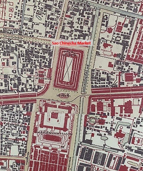
Almost dead center of the map one can see a substantial rectangular shaped building in front of Bangkok’s famous Giant Swing (Sao Chingcha) and Wat Suthat. This was Sao Chingcha Market which was demolished in 1941. Today this area is known as City Square, a rather dismal concrete plaza which covers an underground carpark, in front of the equally dismal concrete edifice of the Bangkok Metropolitan Administration, Bangkok City Hall dating from 1962.
One can imagine that had it had been preserved and renovated Sao Chingcha Market would have made a much more lively and interesting area today, complementing the tourist attractions of the Giant Swing and Wat Suthat.

Palaces

Nineteenth century Bangkok was a city of palaces. Rama IV (r.1851-1868) had 80 wives and concubines and 82 children, whilst Rama V (r.1868-1910) had 152 wives and concubines and 76 children. By the end of the century the city was bursting at the seams due to the enormous number of princes and princesses that required accommodation befitting their status. One outcome was the move by the royal family to Dusit, north of the old city centre. Here Chulalongkorn built modern European style housing for his family located around landscaped gardens and lakes. Today surrounded by modern buildings and traffic it is hard to appreciate, but at this time Dusit would have been an oasis of calm and fresh air compared with the old palace area on Rattanakosin island.
Some of the palaces are still in use by the royal family today such as the Ananta Samakhom Throne Hall, Abhisek Dusit Throne Hall, Amphorn Sathan Residential Hall and Chitralada Palace. But many others were taken over by the government after the 1932 revolution and became government offices or institutions whilst others fell into disrepair and have been demolished. One interesting example is Suan Sunandha Palace seen clearly on our map to the west of the Ananta Samakhom Throne Hall. Construction began after King Chulalongkorn’s second trip to Europe in 1907. The striking Nongkran Samosorn Audience Hall at the centre of the grounds was designed by an Italian architect A. Rigassi, one of many working at that time for the government. King Chulalongkorn took a personal interest in designing the layout of the gardens and the 32 residences around the lakes for his consorts and daughters. As later described by one contemporary “When Suan Sunandha was the residence of female members of the royal family it was one of the most pleasurable places. In the middle of this vast plot of land was a large pond and man made canals dotted naturally with small islets and hills. The area was shady with different kinds of trees.“

After the 1932 revolution Suan Sunandha Palace became government property and today it divided amongst Suan Sunandha Rajabhat University, Suan Dusit Rajabhat University and the Instititute of Administration Development. The old palace grounds are mostly lost to crowded university buildings but six of the old mansions survive including the beautiful Saisudha Nophadon mansion, once home to Princess Saisavali Bhiromya (1862-1929) one of King Chulalongkorn’s favourite consorts.

Where to Go
The map on which this article is based is on display at So Heng Tai Mansion, one of the best preserved nineteenth century Chinese style courtyard house in Bangkok (Ignoring the rather incongruous scuba diving training pool built in the centre). The house is open everyday as a café and well worth stopping at whilst exploring Talat Noi.
Incidentally, after all my musings I came to the conclusion that this map must date from the early 1920’s. So Heng Tai also have on display another Bangkok map which must be about 40 years older. Well worth a look.
References
- Kiatrasamee, Jitima. The Management Plan of Historical Building : Saisuddha – Nobhadol Building in Suan Sunandha Rajabhat University. Silpakorn University, 2008.
- http://www.thaipbsworld.com/the-gentle-life-suan-sunandha-palace-museum-offers-a-welcome-step-back-in-time/
- https://threesilapas.ssru.ac.th/en/page/visualarts
- https://en.wikipedia.org/wiki/List_of_bridges_in_Bangkok

Fascinating, thank you!
LikeLiked by 1 person